I was hanging around in Christchurch enjoying road riding and cafes when Chris and Emily worked their powers of persuasion on me. They assured me it would be an easy trip as Emily had a certain 9 month condition. The weather on the West Coast was supposed to be awful and we had decided not to do the trip that Georgia had planned. Instead, Chris had dreamed up a doozy. The weather looked marginal but it was on the main divide so perhaps we’d get away with it. There wasn’t a lot in the way of delicious native forests but more alpine passes and valleys of tussock and light bush. I agreed to join (apparently I had no choice) and we drove off down to somewhere Ashburton where we stayed the night with Em’s parents in Neroli’s house. Georgia and Patrick turned up in the evening too.
Day 1 – 31/12/2018
We drove to Tekapo and then as far as we could up the Godley without requiring a 4WD. We parked and had a delightful slog 28 km up the valley into a strong Northerly. My pack was fairly heavy and I was not used to the weight and lagged far behind. Georgia and Patrick were also having pack weight issues and stopped for me along the way. We arrived at the Godley Hut later in the evening, cooked dinner and went straight to bed.
")
Above: We set off from the end of the Lilybank Road with smiles on faces. The plan was to walk up the Godley River to the Godley Hut.
")
")
Above left: We headed off for a long slog up the flat Godley valley. Above right: The scenery was impressive in a sparse kind of way.
Day 2
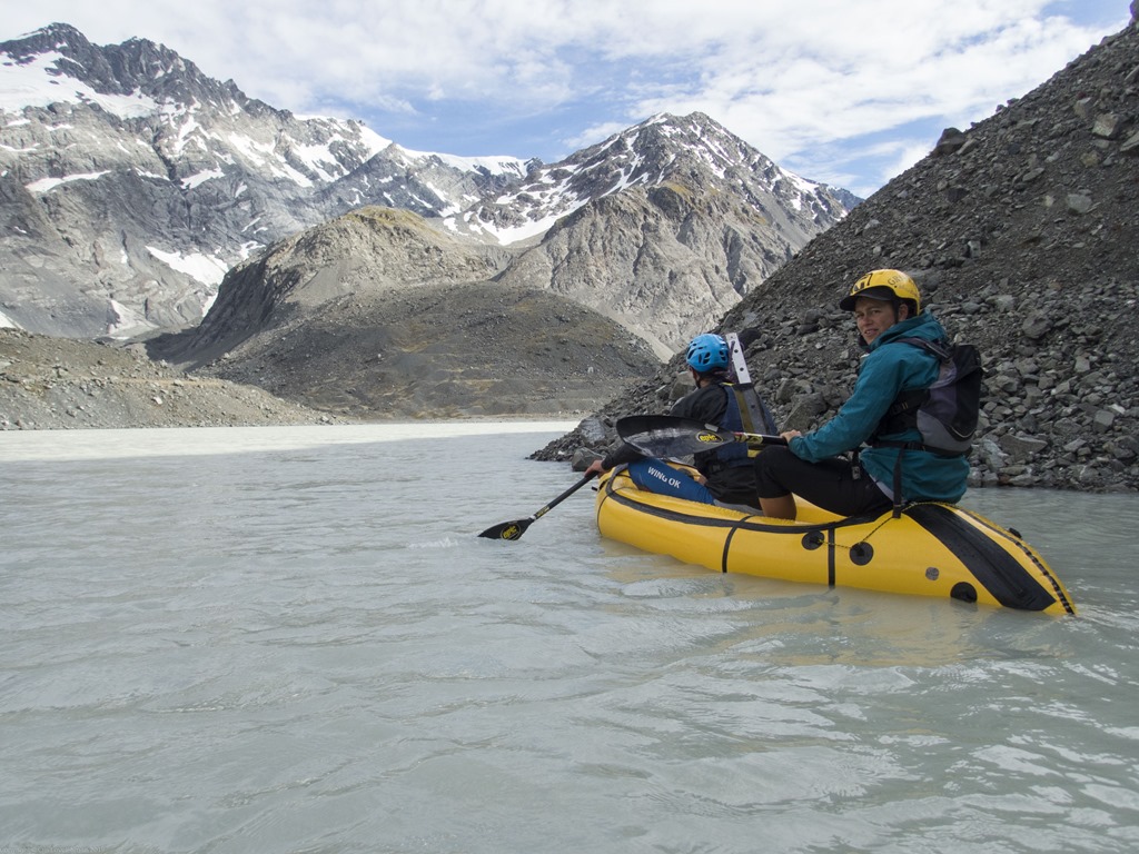
We set off reasonably early and after 1km crossed the terminal lake of the Godley glacier. We were able to cross it as we were carrying pack rafts. Along with the mountaineering gear and six days of food, this explained the weight of our packs. Georgia had lent me her single raft and the others had doubles between them. I drafted Patrick and Georgia across the lake and we deflated the rafts and stuffed them back into our packs. Since the map was created years ago the Godley has receded significantly. Instead of a gentle white descent up to the pass we were faced with a very long moraine bash. The weather was a bit marginal and we had a few spots of rain as we trudged up and down the loose rocks towards the pass. We finally reached snow and ascended for a bit on the glacier before heading up to the right to Terra Nova pass on a snow slope.
It was decided at the pass that I was the crash test dummy and I was sent down on a rope to look for crevasses in the first part of the steep descent. Thankfully I didn’t find any as the light weight alpine harness I had borrowed off the Forne’s would have been horribly uncomfortable if I’d had to hang in it. I set up another snow stake and the others came down to me one-by-one and then descended another 30 metres on our second rope. Possibly the hardest part of the descent was getting down the moraine after we reached the edge of the snow. We had a very steep climb down into the valley followed by a walk down to river flats where we set up camp for the night.
")
Above: The day started with a short walk to the edge of the Godley Glacier’s terminal lake. We inflated our pack rafts and began to paddle across the lake. Chris’ snow stake protruding out of his PFD nicely contrasts the two main activities on the trip. Above right:
")
Above: The glaciers are receding. What looked like an ascent on snow up the Godley Glacier turned into a massive moraine bash. This photo was taken near the top of the Godley Glacier looking across towards Dennistoun Peak. Or thereabouts. By this point there was snow.
")
")
Above: There’s nothing like a good posing session.
")
Above: Due to the outrageous quantities of stuff somehow attached to the outside of Chris’s pack it was given the name The Gypsy Wagon. The wagon was not something that mere mortals should attempt to lift. Even Chris complained about his pack straps trying to cut through his shoulders.
")
Above: I was hoping that the tricky part was over once we reached the pass but the descent proved to require some thought too. Wary of potential cracks on the steep descent I was sent down on belay as crevasse finder. After not finding any I set up a snow anchor and threw the second rope further down the glacier. The others descended both ropes onto flatter snow. We roped up there and continued crossing the glacier. It was probably a good thing I didn’t land in a crack as the harness I had borrowed from Chris, while extremely light, looked like it would not have been so forgiving on tender regions.
")
")
Above left: As we crossed the flatter part of the glacier on the East side of the pass we could see huge cracks in the snow. Above right: The route took us across and down and then up again to the right of the rocks in the top left of the photo.
")
")
Above left: I was in a rope team with Pat and Georgia who certainly look like they were enjoying themselves in this photo. Maybe they were happy to have left the area with the large fissures. Above right: The descent was easy until we got to the moraine wall (not shown in this picture). This proved tricky as the rocks were loose and not good to hold on to and it was steep.
")
Above: It was unsurprisingly late by the time we got to our camp site and began cooking. Here Emily is cooking up a feast at around 10:30pm.
Day 3
The third day was supposed to be our rest day but since we hadn’t got down to the St Winifred’s hut last night that was our job for the day. It was unfortunately raining, heavily. The route, although just a few kilometres, was anything but straightforward. We bashed our way through think bush full of spaniards. My 2-split wing paddle on the side of my pack proved to be incompatible with bush bashing and instead Patrick and I carried a half each. We used the rope to lower packs in one section as we climbed down a tricky bit of rock next to the now raging river. After some hours we reached the confluence of the Eric and Havelock rivers. St Winifreds Hut was less than 1 km away but to get there we had to cross the river and that didn’t look easy. Luckily we had pack rafts. We inflated one of them and Chris paddled it across to the far bank. We used our glacier ropes to pull the boat backwards and forwards across the river deliver packs and people to the other side.
We spent the evening in the hut and the weather improved a bit.
")
Above: We had planned to have a rest day on the third day and frolic around in sunny meadows. Unfortunately, the reality was somewhat different. The issue was we hadn’t made it to the hut on Day 2 as planned because it had got dark. We were only 3 km away from it so we thought that our rest day would at least be short. We were wrong. It turned into a classic NZ bush bash complete with spiky spaniards and impenetrable bush. It wasn’t particularly easy and it took a long time to get anywhere. It was also raining which was bringing up the river and at times we would be hard up against the river and a large cliff on our left. Other times we were forced to ascend through the wet and slippery bush. My paddles proved to be more useful on the water and a hindrance in the bush but Pat kindly offered to carry one.
")
")
Above left: We reached the confluence of the St Winifred and the Eric streams. We needed to cross the St Winifred in order to get to the St Winifreds Hut about 400 m away. The river was up and it didn’t look like something we would want to cross. Instead we inflated a pack raft and using our climbing ropes we ferried people and gear across the swollen river. This worked well. Another win for the pack rafts. Above right: We arrived at the St Winifreds hut late afternoon. The hut was already quite full with a family of hunters that had flown in. They were very friendly and cleared off when we arrived so that we could sort out our piles of wet gear.
Day 4
The weather was looking menacing again and we weren’t sure whether we should abandon, stay in the hut for the night and then walk/packraft out the Havelock the following day. To kill time we decided to head up river a wee way for lunch at a Biv that was marked on the printed version of the topo map we had. This involved inflating a pack raft and crossing the Havelock first. Then a bit of walking up the riverbed. The biv seemed to have vanished and the weather was improving so we headed on further up the river as had been our original plan. This took us to a spur to the true left of the Havelock Glacier. We ascended this finding our way up to Disappointment Saddle. As we neared the saddle the clouds started to part with thin whisps racing over head. This made it very atmospheric. It was very windy at the saddle but after we put on our harnesses and began to descend we got out of the wind. We had a traverse and steep down climb to get into the valley. In the evening we camped at the head of the valley near the Frances River. The weather had improved again and we found a nice place flat mossy place to pitch the tents.
")
Above: The weather was a bit dubious. We decided we may need to alter our plans. We set off in the morning anyway with the intention of finding a biv somewhere up the Havelock for a lunch stop and then coming back down to the hut for the night. We started by crossing the Eric by pack raft. The biv was no where to be seen but by that stage the weather was clearing so we made the decision to continue onwards towards Disappointment Saddle.
")
Above: Blue sky and sunshine! Things we hadn’t seen so much of on this trip. Pat and Georgia slog up the valley towards the Havelock Glacier.
")
")
Above left: The clouds swirled as we ascended the Havelock Glacier creating a very atmospheric feel. It opened up near the top revealing blue sky and sunshine. It was extremely windy and cold on Disappointment Saddle but as soon as we dropped down to the East the wind was gone and it was much more comfortable. Above right: The glacier crumbled at the edge and fell into the valley.
")
Above: It looked so pretty that we took the time to do some posing.
")
")
Above left: We had some steep downclimbing to do which we opted to do without a rope. The snow was soft enough to kick big bucket steps and with an ice axe and a hand it felt pretty ok. Above right: In the evening we found a nice camp site on the river flats next to the Frances River. We spread our belongings out far and wide like some sort of animals climbing their territory. We had cups of soup and enjoyed the lack of rain before preparing dinner.
Day 5
It was sunny when we got up and it looked like it would be a good day. We headed North towards the Frances Glacier. To our West was the Garden of Eden, shown on the topomap as a huge system of glaciers. After so many of the glaciers on the trip so far were much smaller than mapped I wonder how long this area will stay glaciated before turning into an impenetrable moraine fest. We crossed a sandy area beside a glacial lake and began up the long valley leading to Rangitata Col. We left the Frances Glacier and had a rock scramble up towards the Col followed by more walking up a snowfield. The sun was out and we had great views down to the Frances. We navigated some tricky terrain roped up and ended up on a snowy lip. I became crevasse finder again and Chris lowered me off the lip with one of our 30 m ropes. I stuck a snow anchor in and waited while Chris lowered the others down the rope. We then continued down snow slopes that took us all the way down to the glacier below. The views were spectacular.
We walked down the Lyell Glacier which from the above had looked like a mass of cracks and fissures. The view had been accurate and we walked a over ice with large visible crevasses – no snow. The glacier was amazing. It seemed to be melting rapidly. Little rivers of water ran together forming larger rivers which would abruptly disappear deep into the depths of the glacier. At times you could hear what sounded like large amounts of running water deep below. It was hard to know whether we were standing on solid ice or whether the glacier had perhaps melted out underneath and we were walking over something that could break away. It felt safe probably because all the crevasses were easy to see and the ice felt solid but who knows…
The ice finished and we hit moraine. It was easy to think we were just walking along piles of rock on solid ground but a huge sink hole along the way confirmed that it was still glacier underneath. The most impressive part was the descent off the head wall of the glacier. Conveniently the glacier had melted where we were descending leaving a massive arch made out of ice. This allowed us to descend more easily and it looked amazing. I tried to take some photos but it’s share size made it very difficult to get a good perspective on it.
")
Above: Day 5 was sunny and we set off coming to a lake at the bottom of the the Colin Campbell Glacier. At least it’s marked as a glacier on the map. I certainly didn’t see any snow. It felt like we were on the beach. There were even a few confused sea birds.

")
Above left: We headed up the Frances Glacier to Rangitata Col. The route over the col leaves the glacier and climbs steeply up to the right (out of shot). Above right: The weather really was perfect. Sunny and wind-still. We had a great view down the Frances Glacier during the climb to Rangitata Col.
")
")
Above left: We roped up at Rangitata Col and began a slow descent and sidle towards McCoy Col. The crux was coming up. Above right: I stopped our rope team for a selfie.
")
Above: Cloud back around the Frances began to spill over onto our side of the glacier.
")
Above: The crux to getting off Rangitata Col was the ridge leading East from Mt Nicholson. Here there was a little section on the map that looked passable. Going straight down the Lyell Glacier wasn’t an option.
")
Above: We had a nice snowy descent that was good for posing.
")
Above: This huge bridge of ice was at the bottom of the Lyell Glacier. The glacier is melting away (quickly it seems) and this was the most impressive feature amongst the large sink holes in the morraine. The photo does not do it justice. It’s hard to capture the size of the arch. It was massive. Further up the glacier there was endless ice, no snow, just hard ice and small stones. All through the ice there were little channels of running water. Sometimes these would disappear deep into the glacier and the sound of large volumes of rushing water could be heard. It was fascinating. I spent a long time looking at the channels and pools of clear, cold, glacial water lagging well behind the others as we descended. It was the most amazing place. Who knows how long it will be there for.
")
")
Above left: After crossing the Lyell Glacier with it’s amazing ice features we paddled across the terminal lake. Pat and Georgia gave me a bit of a tow to make things more efficient. Above right: We had intended to stay in Lyell Hut near the river but rats had beaten us to it and made a real mess so we headed back down to the river and camped there instead.
Day 6
We awoke to more sunshine at our campsite by the river. The plan was to spend most of the day packrafting and we started off by inflating a raft and crossing the river. Then it was a 3km-ish walk down river followed by another crossing. This time with all rafts. Soon after this we tried to begin pack rafting the Rakaia but after some quite exciting rapids decided that we’d prefer to start further down stream. So we packed up again and headed off. The weather was starting to deteriorate slowly from the West and the wind was getting up. We got on the river again and spent perhaps 6 hours outrunning the approaching storm. It was amazing. We managed mostly to keep just in front of it and so we could look back and see the dark clouds as the wind helped push us downstream. In the evening the clouds lead to the most amazing light on the bare hills. Unfortunately due to the kayaking I couldn’t do a lot of filming or photography. There was one memorable point where our branch of the river with it’s glacial turquoise coloured water joined another branch of darker green water and I watched the water swirl around and mix together. Beautiful.
We only got onto the river at 3 pm so we had to abandon our initial plans of pack rafting all the way to the bridge at the Rakaia Gorge. Instead we managed to contact Emily’s parents somewhere along the way and got off the water a bit after 9pm. After packing and walking to the road we waited no more than a minute before getting picked up by Dave and Pat Bodger.
")
Above left: We got onto the water of the Rakaia but it was a bit too adventurous so we got out again and decided to portage for a few km. Pat was keen to rival Chris’ gypsy wagon (or was he just less keen to pack everything away again). Above right: The first section of the Rakaia was far too adventurous for my liking. Well, more that I didn’t feel like that much adventure so late in the trip but the others also got sick of tipping out. I probably had the best setup with my single pack raft and spray deck. After our portage we got back onto the water which was then much more gentle. The weather was deteriorating to the west from where we had come. A big tail wind pushed us down the river and we had a constant battle to stay in front of the storm. It was exciting and really dramatic to see the big clouds chasing us. At one point we past the confluence of the Rakaia and another river. There was an amazing mixing effect of turquoise glacial water and a much darker green water. The colours swirled together. We continued paddling sometimes rain drops started to fall and it looked like the storm would catch us but then we would get ahead again.
")
Above: We managed to communicate with our pickup and arranged for them to meet us further up the river. Our original plan was to head down to the Rakaia bridge but it was around 9 pm by the time we got off the water. We met Dave Wall and Pot Bodger. It was great to see them and head back tired to Neroli’s house for the night.