I went and stretched my legs in the Vogesen mountains in France today. I left Freiburg at the suitably lazy time of 11 am-ish and rode the 20 km or so to the French border. I crossed the Rhine there and headed North-West towards Colmar. Instead of riding into Colmar I headed West into a valley leading into the Vogesen mountains. At Munster I headed South towards a pass, Col du Platzerwasel (1183 m). At the bottom of the ascent there were ominous closure signs but I decided to ride a little bit of the climb and see what was what. It was already something like 3:30 pm. I told myself I should turn around soon in order to get back before it got dark but kept riding a little further. I reached the pass and was curious to go jusssttt a little further. I ended up at Le Breitfirst (1280 m), another pass close to the first one. I only had my cell phone to navigate with and there wasn’t any height profile on the map so I wasn’t sure that continuing onwards was such a sensible idea. Therefore I continued onwards. It got quite snowy on either side of the road and began to snow lightly. I met some people and asked about the road and we flagged down a car and consulted their real map. It looked like I’d be able to continue without having to climb again. It was now getting quite late and I had to ride hard to get back to Freiburg before dark. I did some premium descending and then battled back across the plains to Germany racing the clock and arriving around 9 pm as it was getting dark. A good day in the saddle.
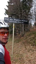
Above left: Storks in Munster, France. Above right: Arriving at Col du Platzerwasel. I got there a little late which meant I had to scurry quickly back to Freiburg as fast as my tired legs would take me.
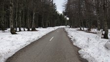
Above: As the snow beside the road increased and it got later I wondered whether I wasn’t being a bit foolish. I navigated using my cell phone with a little map without contour lines.
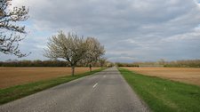
Above left: Crossing the border back to Germany at Fessenheim. Above right: The long haul back across the plains.
Freiburg -> Vogesens (Col du Platzerwasel) Time: 07:35:21 Dst: 186.03 km Avg: 24.51 km/h Max: 68.42 km/h Avg Cad 70


